Today with satellite photos, LIDAR, GPS and all the other modern tools we take knowing exactly where something is located for granted. I started caving years ago, and the standard was USGS topographic maps. With a quadrangle, compass and some eyeball work, you could figure your location to within a few hundred feet. We assumed that the contour map was 100% correct and any error was our lack of skills.
The internet has given us tremendous tools for today and has also brought to the surface tools from long ago: old maps. A couple of good sites have archives of maps dating back almost 2000 years. I’ve downloaded many maps covering the Arkansas area going back 500 years.

Going backwards from today, it’s interesting to see what towns and railroads disappear and appear. As you go far enough, rivers start to change. The Buffalo River didn’t show up on maps prior to 1840 or so.

One map shows what I suspect is the upper section of the Buffalo, but sends it down to connect to the Red River.

A map in 1844 puts the Buffalo in place, but straightens out bends.

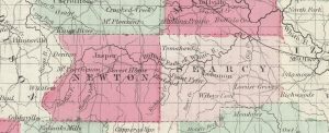
An 1855 map gets us pretty close to today.